


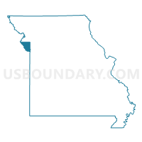
Platte County PUMA, Missouri
About
Outline

Summary
| Unique Area Identifier | 193281 |
| Name | Platte County PUMA |
| State | Missouri |
| Area (square miles) | 430.04 |
| Land Area (square miles) | 423.42 |
| Water Area (square miles) | 6.62 |
| % of Land Area | 98.46 |
| % of Water Area | 1.54 |
| Latitude of the Internal Point | 39.37869570 |
| Longtitude of the Internal Point | -94.76147170 |
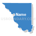
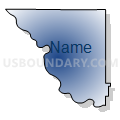
Maps

Graphs
Select a template below for downloading or customizing gragh for Platte County PUMA, Missouri


Neighbors
Neighoring Public Use Microdata Area (by Name) Neighboring Public Use Microdata Area on the Map
- Buchanan, Andrew & DeKalb Counties PUMA, MO
- Clay County (Northeast) PUMA, MO
- Johnson, Lafayette, Ray, Clinton & Caldwell Counties PUMA, MO
- Kansas City (North Central), Gladstone City & North Kansas City PUMA, MO
- Northeast Kansas PUMA, KS
- Wyandotte County--Kansas City PUMA, KS
Top 10 Neighboring County (by Population) Neighboring County on the Map
- Clay County, MO (221,939)
- Wyandotte County, KS (157,505)
- Platte County, MO (89,322)
- Buchanan County, MO (89,201)
- Leavenworth County, KS (76,227)
- Clinton County, MO (20,743)
- Atchison County, KS (16,924)
Top 10 Neighboring County Subdivision (by Population) Neighboring County Subdivision on the Map
- Kansas City city, Wyandotte County, KS (145,786)
- Gallatin township, Clay County, MO (68,393)
- Chouteau township, Clay County, MO (50,819)
- May township, Platte County, MO (23,500)
- Platte township, Clay County, MO (16,470)
- Carroll township, Platte County, MO (14,970)
- Fox township, Platte County, MO (11,791)
- Sioux township, Platte County, MO (11,497)
- Lansing city, Leavenworth County, KS (11,265)
- Atchison city, Atchison County, KS (11,021)
Top 10 Neighboring Place (by Population) Neighboring Place on the Map
- Kansas City city, MO (459,787)
- Kansas City city, KS (145,786)
- Gladstone city, MO (25,410)
- Lansing city, KS (11,265)
- Atchison city, KS (11,021)
- Smithville city, MO (8,425)
- Parkville city, MO (5,554)
- Platte City city, MO (4,691)
- Riverside city, MO (2,937)
- Weatherby Lake city, MO (1,723)
Top 10 Neighboring Unified School District (by Population) Neighboring Unified School District on the Map
- North Kansas City School District, MO (123,348)
- Kansas City Unified School District 500, KS (115,219)
- Park Hill School District, MO (62,261)
- Leavenworth Unified School District 453, KS (26,901)
- Platte County R-III School District, MO (22,548)
- Lansing Unified School District 469, KS (14,456)
- Atchison Public Schools Unified School District 409, KS (12,435)
- Smithville School District, MO (11,921)
- Fort Leavenworth Unified School District 207, KS (7,824)
- Clinton County R-III School District, MO (5,430)
Top 10 Neighboring State Legislative District Lower Chamber (by Population) Neighboring State Legislative District Lower Chamber on the Map
- State House District 35, MO (58,725)
- State House District 38, MO (45,769)
- State House District 32, MO (43,330)
- State House District 30, MO (42,652)
- State House District 5, MO (38,074)
- State House District 29, MO (35,957)
- State House District 31, MO (34,655)
- State House District 36, KS (27,098)
- State House District 42, KS (27,057)
- State House District 63, KS (22,789)
Top 10 Neighboring State Legislative District Upper Chamber (by Population) Neighboring State Legislative District Upper Chamber on the Map
- State Senate District 17, MO (199,316)
- State Senate District 34, MO (178,523)
- State Senate District 12, MO (169,332)
- State Senate District 3, KS (81,860)
- State Senate District 5, KS (75,528)
- State Senate District 1, KS (69,919)
- State Senate District 4, KS (62,358)
Top 10 Neighboring 111th Congressional District (by Population) Neighboring 111th Congressional District on the Map
- Congressional District 3, KS (767,569)
- Congressional District 2, KS (710,047)
- Congressional District 6, MO (693,974)
Top 10 Neighboring Census Tract (by Population) Neighboring Census Tract on the Map
- Census Tract 303.05, Platte County, MO (8,221)
- Census Tract 9819, Leavenworth County, KS (7,815)
- Census Tract 302.09, Platte County, MO (7,799)
- Census Tract 300.01, Platte County, MO (7,735)
- Census Tract 213.05, Clay County, MO (7,447)
- Census Tract 306, Platte County, MO (7,154)
- Census Tract 212.06, Clay County, MO (7,118)
- Census Tract 213.06, Clay County, MO (6,989)
- Census Tract 302.05, Platte County, MO (6,689)
- Census Tract 212.05, Clay County, MO (6,511)
Top 10 Neighboring 5-Digit ZIP Code Tabulation Area (by Population) Neighboring 5-Digit ZIP Code Tabulation Area on the Map
- 64118, MO (40,191)
- 66048, KS (35,475)
- 64152, MO (26,024)
- 66104, KS (25,401)
- 64151, MO (24,134)
- 64155, MO (21,901)
- 66109, KS (20,480)
- 64116, MO (15,318)
- 66002, KS (13,755)
- 64079, MO (12,485)